For this class, we headed south of UWEC about 10 minutes to Eau Claire's South Middle School Garden to fly the DJI Phantom 3 Advanced and the DJI Inspire a bit. This served as a visual and physical learning experience to see what actually goes into flying a UAV for geospatial analysis.
Methods
We arrived at the garden around 3 pm and first started by laying out the ground control points (GCPs). Since the garden was the area being flown, nine GCPs were laid out in three rows by three columns, ensuring to cover each corner of the garden. Figures 1 and 2 show the garden and a GCP placed within the garden's fence.
 |
| Figure 1: South Middle School's garden. |
 |
| Figure 2: GCP laid out in garden. |
The GCPs we used had numbers on them, so we made sure to put them in sequentially ordered snake pattern. From there, we used a survey-grade global positioning system (GPS) ground station that gave coordinates to the GCPs. Figure 3 shows a classmate using the GPS receiver to collect coordinates of a GCP.
 |
| Figure 3: Giving GCPs coordinates with ground station. |
 |
| Figure 4: "Mi-Fi" personal Wi-Fi hotspot. |
Finally, after completing the software update, the Phantom was ready to fly. Here is a video of the phantom's take-off from the first flight:
The first flight was an aerial coverage of the garden, and the second flight was an oblique (camera set at 75 degrees) coverage of the class's cars. After two successful flights with the Phantom, we moved to the DJI Inspire; a bit heavier and more powerful UAV. Figure 5 shows a classmate attaching the rotor blades on the Inspire and figure 6 shows a classmate holding the two different sensor options we have for the Inspire.
 |
| Figure 5: Attaching rotor blades to Inspire. |
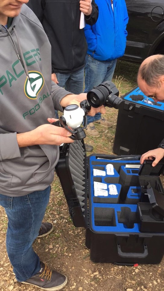 |
| Figure 6: Two sensor options for the DJI Inspire. |
Results
The imagery from the first flight was processed in Pix4D, and produced an orthomosaic and digital surface model.
 |
| Figure 7: Orthomosaic map produced with imagery from flight one. |
 |
| Figure 8: Digital Surface Model map produced with processed imagery from flight one. |
Discussion
Looking at figure 7, the orthomosaic imagery offers a fairly crisp and detailed rendering of the garden, and the different agricultural plots are distinct and identifiable. I chose not to include the basemap as the orthomosaic image was inaccurately placed in some parts of the extent. This is interesting, because in the digital surface model (DSM) displayed in figure 8, the imagery appears to line-up fairly well with the basemap. Some of the color displayed in the imagery is a bit off as well, specifically the ground beneath the trees that line the garden. The image makes these areas appear a vibrant maroon-ish color, when in actuality, these areas are not as saturated.
Looking at figure 8, the trees (shown in bright red) are a bit distracting to the area of interest; the garden. While an accurate representation of the surface elevation, the sheer height of the trees takes away some of the elevation exaggeration that could be present in the garden. It is interesting to see the slight elevation change near the east side of the imagery, however. The DSM did turn out quite well, despite the somewhat interfering tree line, and shows in great detail the surface elevation of the area.
Overall, being able to see the entire process of analyzing data collected from a UAV was incredibly exciting and engaging. Everything from making the GCPs used in the field, to flying the drones, and processing the imagery, really puts the whole process into perspective.
No comments:
Post a Comment